Product
Use Cases
How it Works
Pricing
Login

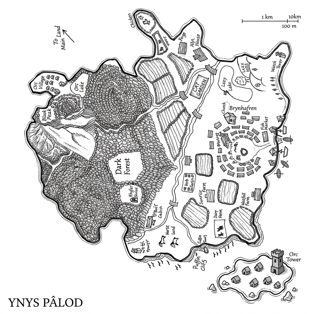
AI image design: Use the supplied reference images as the exact cartographic blueprint. Recreate the illustrated map with maximum fidelit…
Back to community
Use the supplied reference images as the exact cartographic blueprint. Recreate the illustrated map with maximum fidelity to the reference artwork. Do not redesign, reinterpret, simplify, rearrange, add, remove, or invent any geographic feature, landmark, settlement, road, river, field, forest, mountain, lake, bridge, structure, symbol, icon, texture, label placement, or decorative element.

Carefully reproduce every visible detail from the reference, including the smallest hand-drawn symbols and environmental markings. Preserve the exact relative position, scale, orientation, spacing, density, and hierarchy of all elements. The second reference shows the smaller western island and must be reproduced with all of its original details. The third reference shows the larger map section and must likewise be reproduced in full detail. Treat all three references as interconnected sections of the same illustrated world map.

Cartographic accuracy is the highest priority. Match the original references feature-for-feature. Maintain the exact relationships between forests, mountain ranges, lakes, rivers, agricultural plots, settlements, buildings, roads, bridges, coastlines, cliffs, harbours, watchtowers, temples, villages, ruins, landmarks, and other illustrated locations. Do not substitute generic fantasy-map symbols for specific details visible in the references.

Preserve the hand-drawn character of the original while elevating it into a professional fantasy-cartography illustration suitable for a published D&D campaign setting, fantasy novel, worldbuilding book, or premium tabletop RPG sourcebook.

Art style: traditional black-ink cartographic engraving, highly refined pen-and-ink illustration, extremely precise linework, controlled stippling, fine cross-hatching, varied line weights, delicate contour lines, dense botanical textures, carefully rendered mountain relief, engraved architectural details, miniature hand-drawn buildings, elegant fantasy cartography, professional historical-map craftsmanship.

Forests should retain the individual-tree texture and density of the reference. Mountains should use detailed engraved rock formations and directional hatching. Agricultural areas should retain their individual field boundaries and repeated crop-line textures. Water should remain clean and largely unfilled, with subtle contour/detail lines where present in the reference. Buildings and settlements should remain individually legible rather than becoming abstract symbols.

Reproduce all handwritten labels and place names from the reference as accurately as possible, maintaining their approximate typography, scale, orientation, and location. Do not replace labels with invented names. Do not omit difficult-to-read labels; inspect the reference carefully and reproduce the visible lettering faithfully.

Preserve the original visual hierarchy: heavily textured natural regions, lighter inhabited/open regions, clearly defined waterways and roads, prominent landmarks, and fine peripheral details. Keep the illustration monochromatic and entirely ink-based.

Clean professional finish: crisp high-resolution black linework, consistent ink density, extremely fine details, clean contours, subtle organic imperfections characteristic of hand-drawn cartography, no digital-looking vector smoothness, no colour, no grey wash, no painterly rendering.

Background: pure solid white (#FFFFFF), completely clean and uninterrupted. The map illustration and its details are the only visual content.

Composition: reproduce the reference artwork faithfully within the image area. Do not introduce a decorative parchment background, compass rose, border, title, legend, ornamental frame, grid, scale bar, typography panel, shadows, stains, paper texture, or any element that is not present in the reference.

CRITICAL REFERENCE-FIDELITY RULE: the supplied images are not inspiration; they are the source artwork to be faithfully reconstructed. Prioritize exact visual correspondence over artistic interpretation. Every recognizable feature in the references should remain present and in its correct relative position. Do not make the map “better” by changing its design — only refine the execution, line quality, consistency, legibility, and professional finish while preserving the original information and details exactly.

Negative instructions: no colour, no parchment, no aged paper, no fantasy redesign, no new landmarks, no missing landmarks, no altered geography, no simplified forests, no generic settlements, no rearranged buildings, no invented text, no omitted details, no decorative additions, no cinematic lighting, no 3D rendering, no photorealism, no watercolor, no painting, no vector-flat aesthetic, no modern infographic aesthetic.

Community

Design detail

Elephant_1649093

Creator

@Elephant_1649093

Created September 24, 2026
Prompt

Use the supplied reference images as the exact cartographic blueprint. Recreate the illustrated map with maximum fidelity to the reference artwork. Do not redesign, reinterpret, simplify, rearrange, add, remove, or invent any geographic feature, landmark, settlement, road, river, field, forest, mountain, lake, bridge, structure, symbol, icon, texture, label placement, or decorative element. Carefully reproduce every visible detail from the reference, including the smallest hand-drawn symbols and environmental markings. Preserve the exact relative position, scale, orientation, spacing, density, and hierarchy of all elements. The second reference shows the smaller western island and must be reproduced with all of its original details. The third reference shows the larger map section and must likewise be reproduced in full detail. Treat all three references as interconnected sections of the same illustrated world map. Cartographic accuracy is the highest priority. Match the original references feature-for-feature. Maintain the exact relationships between forests, mountain ranges, lakes, rivers, agricultural plots, settlements, buildings, roads, bridges, coastlines, cliffs, harbours, watchtowers, temples, villages, ruins, landmarks, and other illustrated locations. Do not substitute generic fantasy-map symbols for specific details visible in the references. Preserve the hand-drawn character of the original while elevating it into a professional fantasy-cartography illustration suitable for a published D&D campaign setting, fantasy novel, worldbuilding book, or premium tabletop RPG sourcebook. Art style: traditional black-ink cartographic engraving, highly refined pen-and-ink illustration, extremely precise linework, controlled stippling, fine cross-hatching, varied line weights, delicate contour lines, dense botanical textures, carefully rendered mountain relief, engraved architectural details, miniature hand-drawn buildings, elegant fantasy cartography, professional historical-map craftsmanship. Forests should retain the individual-tree texture and density of the reference. Mountains should use detailed engraved rock formations and directional hatching. Agricultural areas should retain their individual field boundaries and repeated crop-line textures. Water should remain clean and largely unfilled, with subtle contour/detail lines where present in the reference. Buildings and settlements should remain individually legible rather than becoming abstract symbols. Reproduce all handwritten labels and place names from the reference as accurately as possible, maintaining their approximate typography, scale, orientation, and location. Do not replace labels with invented names. Do not omit difficult-to-read labels; inspect the reference carefully and reproduce the visible lettering faithfully. Preserve the original visual hierarchy: heavily textured natural regions, lighter inhabited/open regions, clearly defined waterways and roads, prominent landmarks, and fine peripheral details. Keep the illustration monochromatic and entirely ink-based. Clean professional finish: crisp high-resolution black linework, consistent ink density, extremely fine details, clean contours, subtle organic imperfections characteristic of hand-drawn cartography, no digital-looking vector smoothness, no colour, no grey wash, no painterly rendering. Background: pure solid white (#FFFFFF), completely clean and uninterrupted. The map illustration and its details are the only visual content. Composition: reproduce the reference artwork faithfully within the image area. Do not introduce a decorative parchment background, compass rose, border, title, legend, ornamental frame, grid, scale bar, typography panel, shadows, stains, paper texture, or any element that is not present in the reference. CRITICAL REFERENCE-FIDELITY RULE: the supplied images are not inspiration; they are the source artwork to be faithfully reconstructed. Prioritize exact visual correspondence over artistic interpretation. Every recognizable feature in the references should remain present and in its correct relative position. Do not make the map “better” by changing its design — only refine the execution, line quality, consistency, legibility, and professional finish while preserving the original information and details exactly. Negative instructions: no colour, no parchment, no aged paper, no fantasy redesign, no new landmarks, no missing landmarks, no altered geography, no simplified forests, no generic settlements, no rearranged buildings, no invented text, no omitted details, no decorative additions, no cinematic lighting, no 3D rendering, no photorealism, no watercolor, no painting, no vector-flat aesthetic, no modern infographic aesthetic.

Remix this design

Start for free with full control over models, settings, and canvas tools.

  • ·Generate with full control over models and settings
  • ·Save projects and share back to the community
  • ·No design experience required
Start free — use this prompt
Browse more community designs →
Start free — remix this

What's next?Explore more features

Hiding Elephant product features overview

Explore features

AI generation, vector tools, workflows, catalogs, and collaboration in one workspace.

How Hiding Elephant works

How it works

See how the AI canvas, automation, and teamwork fit together end to end.

Get started with Hiding Elephant

Try it free

Sign in and turn inspiration into projects you can edit, export, and share.

Go from browse to build

Explore what else the Elephant can do.You'll love it

AI image generation

AI Generation

Image tools

Image Tools

Workflow builder

Workflows

Brand and style templates

Brand Management

Product catalog

Product Catalog

Collaboration

Collaboration

Batch image generation

Batch generation

Explore community

Community workflows

The AI designworkspace forfast-moving ideas.

Product

  • AI Generation
  • Vector Canvas
  • Image Tools
  • Workflows
  • Brand Management
  • Product Catalog
  • My Assets
  • Collaboration

Use Cases

  • E-commerce teams
  • Design agencies
  • Marketing teams
  • Content creators

Quick tools

  • All quick tools
  • Background Remover
  • Image Upscaler
  • Image Vectorizer
  • Image Optimizer
  • Image Reframer

Resources

  • About
  • Pricing
  • FAQ
  • Compare
  • Enterprise
  • Explore
  • Blog
  • Contact Us
  • Book a Demo
  • Affiliates

© 2026 Hiding Elephant. All rights reserved

Cookie PolicyPrivacy PolicyTerms of Service
Hiding Elephant